SC, Tn, Congaree & Great Smokey Mountains NPs

May 12 - 17, 2024
Sunday, May 12
Weather: Good travel weather
Saint Charles to Columbia South Carolina
Arrived early to the airport around 9:30 with our flight scheduled for 11:25 (with TSA Precheck we can go a little later to the airport in the future). Our flight was delayed until 1:00PM. Fortunately, we had our free United Lounge passes and spent the time comfortably in the lounge. I had breakfast and later a little lunch too!
Made it to Columbia late afternoon, to late to go to the park, and just headed to the hotel (Hilton Home 2 Suites.... NOT recommended, we will not stay there again.) Before dinner we went to the Congaree River Walk that runs through Columbia. The walk goes for miles but unfortunately, due to damage, the walk was mostly closed. We Walked what we could and saw some very cool houses along the river front.
Columbia River Walk


Went to dinner at Liberty Bar and Grill in downtown Columbia. Kathryn had Low Country Shrimp and Grits and I had a Blue Burger. Service was good and the food was tasty!
Monday, May 13
Weather: Overcast but no rain
About Congaree National Park
Congaree National Park is a 26,692.6-acre (41.7 sq mi; 108.0 km2) American national park in central South Carolina, 18 miles southeast of the state capital, Columbia. The park preserves the largest tract of old growth bottomland hardwood forest left in the United States. The lush trees growing in its floodplain forest are some of the tallest in the eastern United States, forming one of the highest temperate deciduous forest canopies remaining in the world. The Congaree River flows through the park. About 15,000 acres (23.4 sq mi; 60.7 km2) are designated as a wilderness area.
The park preserves a significant part of the Middle Atlantic coastal forests ecoregion.[9] Although it is frequently referred to as a swamp, it is largely bottomland subject to periodic inundation by floodwaters.[2]
It has been designated an old growth forest and part of the Old Growth Forest Network. The park also has one of the largest concentrations of champion trees in the world, with the tallest known examples of 15 species. Champion trees include a 167-foot (51 m) 361-point loblolly pine, a 157-foot (48 m) 384-point sweetgum, a 154-foot (47 m) 465-point cherrybark oak, a 135-foot (41 m) 354-point American elm, a 133-foot (41 m) 356-point swamp chestnut oak, a 131-foot (40 m) 371-point overcup oak, and a 127-foot (39 m) 219-point common persimmon.[10][11]
Large animals possibly seen in the park include bobcats, deer, feral pigs, feral dogs, coyotes, armadillos, turkeys, and otters. Its waters contain interesting creatures like amphibians, turtles, snakes, and many types of fish, including bowfin, alligator gar, and catfish. You can read more about the park here: Congaree National Park.
Columbia to Congaree National Park
The 1/2 hr drive to the park was mostly two lane highway with towering 130' trees on both sides guiding us down the highway (a preview of the trees in the park!).
Talking to the Ranger at the visitor center 90% of the trails are under water due to flood levels in the park (we already knew it from the web site). She gave us the 4 trails that were not under water. Fortunately, the mosquito index was very low (1.5).
Hiking Congaree NP
Started on the Upper Boardwalk until getting to the flooded lower boardwalk. Turned around, found the Sims Trail, took that until it was flooded (I was attacked by black flies on this trail). Turned around and found our way to the Firefly Trail (at night firefly mating dances are seen on this trail) then to the Bluff trail, then to the Long leaf trail. We were close to the VC at this point and headed there for bug spray and a blast of A/C (hot and humid on the trail). Back tracked the Long Leaf Trail and finished the trail, then back to the Bluff, Firefly and Upper Boardwalk trails ending back at the VC. Managed to get 5 miles in and enjoyed walking over the swamp on the boardwalk trail. All trails lightly trafficked. Hiking was very nice and peaceful with trees emerging from the swamp and towering 130' above us.
Back at the VC we had a picnic lunch to finish a really nice day in the park.


Back in Columbia we went to Back Streets Grill. We had a Shrimp appetizer and Kathryn had Tilapia and I had a prime rib sammy with Beers. Tasty!
Tuesday, May 14
Weather: Rain Predicted All Day ... but we beat the rain!!
Checked out of our hotel in Columbia and drove the 4+hr drive to the North Carolina entrance to the Great Smokey Mountains NP. The drive was tedious with lots of construction and lots of rain. Finally, arriving at the Oconaluftee Visitor Center we spoke to the ranger and planned two hikes.
About the Great Smokey Mountains National Park
A Wondrous Diversity of Life Ridge upon ridge of forest straddles the border between North Carolina and Tennessee in Great Smoky Mountains National Park. World renowned for its diversity of plant and animal life, the beauty of its ancient mountains, and the quality of its remnants of Southern Appalachian mountain culture, this is America's most visited national park. Geology View of Chimney Tops. The rocks that form the knife-edged "backbone" of the Chimney Tops are visible beneath lush vegetation. Most of the rocks in Great Smoky Mountains National Park are sedimentary and were formed by accumulations of clay, silt, sand, gravel, and minor amounts of calcium carbonate in flat-lying layers. The oldest sedimentary rocks were formed during the Proterozoic Era some 800-545 million years ago. Vast amounts of unconsolidated clay, silt, sand, and pebbles were washed down into lowland basins from adjacent highlands. Rocks of the old highlands were over one billion years old, and were similar to the ancient granite and gneiss found in the southeastern parts of the park. These early sites of ocean bottom deposition were formed along the ancient margin of the North American continent as an older and larger supercontinent broke apart. As more and more of these sediments were deposited, they were eventually cemented together and changed into layers of rock over nine miles thick. Today these rocks are known as the Ocoee Supergroup and are subdivided into many smaller divisions of differing rock types. The different rock types reflect the range of climatic and topographic conditions that existed during their formation. The younger rocks of sedimentary origin formed during the Paleozoic Era, 450 to about 545 million years ago. These consist of compacted and cemented sand, silt, and clay deposited in an ancient shallow marine continental margin that existed in what is now the Appalachian region. Burrows and trails of worms, as well as small shells of crustaceans that lived in this shallow water along the ancient continental edge, are found in sandstone and shale in the northwestern part of the park. Fossils found in limestone rocks in Cades Cove are about 450 million years old. Mountain Building Between about 310 and 245 million years ago, the eastern edge of the North American tectonic plate collided with the African tectonic plate becoming part of a "supercontinent" known as Pangaea. Continental collisions take place at a rate of a few inches per year over many millions of years and are the result of continuing global-scale plate tectonics. Evidence of earlier plate tectonic geologic events are found in rocks of the Great Smoky Mountains, attesting to an incredibly long and active geologic history in this area. During one of these earlier continental collisions, tremendous pressures and heat were generated, which changed or "metamorphosed" the Smokies sedimentary rocks. For example, sandstone became recrystallized to metasandstone or quartzite, and shale became slate. The last great episode of mountain building uplifted the entire Appalachian mountain chain from Newfound-land, Canada to Alabama. These mountains probably were much higher than today, with elevations similar to today's Rockies. As the African tectonic plate gradually pushed against the edge of the North American plate, the original horizontal layers of the rocks were bent or folded and broken by faults. Huge masses of older, deeply buried rocks were pushed northwestward, up and over younger rocks along a large, nearly flat-lying thrust fault, known as the Great Smoky Fault. You can read more about the park here: Great Smokey Mountains National Park.
View from a couple over looks entering Great Smokey Mountains NP


River Trail Hike
First hike was the River Trail hike right from the VC. Clouds were forming so we wanted to get a quick hike in before the rain. It was a nice hike (3 miles) and we saw an elk in the field (next to the sign that said 'Elk Grazing') and we did get caught in the rain on the way back. No problem. Back at the VC we had our picnic lunch (cheese sammies with mustard and apples, tasty!).


 VIDEO
VIDEO  VIDEO
VIDEO Kaphart Prong Trail Hike
Drove 7 miles North on Hwy 441 into the park to the Kaphart Prong trail head. Hiked this trail mostly in the rain making it quite and peaceful with little traffic. Spotted another elk grazing in the woods. 4.4 miles and 980' in elevation along the river. Awesome even in the rain!!


 VIDEO
VIDEO  VIDEO
VIDEO  VIDEO
VIDEO The Smokies
After the hike we drove Hwy 441 North through the park (nice drive, lots of S-turns but no cliffs) stopping at some of the over looks to witness the "Smokey" Mountains.


 VIDEO
VIDEO We are staying at an Airbnd in the quaint (touristy) town of Gatlinburg near the West entrance to the park. Went to dinner at Smokey Mountain Brewery in Pigeon Forge (maybe even more touristy than Gatlinburg). The food was good but the music was terrible. Disco... and bizarre.. they only played 30 seconds of a song then onto the next song over and over (what the hell?). We won't be back. After dinner stopped for groceries at Publix then back to the bnb.
A great day in the Smokey's even with the rain.
Wednesday, May 15
Weather: Overcast, rain predicted all day
Bnb View of the Smokies
The overcast view of the smokies from our bnb.


Porters Creek to Fern Falls Hike
Drove to the Greenbriar area in the North East of the park driving down a long gravel one lane road to the trail head. A remote area but, already cars were parked at the trail head so glad we got an early start (~8am).
Overcast and some rain on the hike but no problem. The hike along the Little Pigeon River was incredible and we traversed 4 foot log bridges the last right over the falls section. The hike was out and back, 4 miles / 890' elev gain, lightly trafficked. Amazing hike (my favorite).


 VIDEO
VIDEO  VIDEO
VIDEO  VIDEO
VIDEO Sugarlands Visitor Center and Old Sugarlands Trail
Sugarlands visitor center is near the Gatlinburg North entrance to the park and is the busiest visitor center in the country. So, I was nervous arriving around noon it would be all parked up. As Kathryn was pulling up to the parking lot a spot opened up and we snagged it. Better lucky than good!
After a visit with the ranger and a pic of a friendly Bermise Mountain Dog, we had our picnic lunch at the vc before our next hike.
Another great trail (not as good as the first hike tho). We hiked out and back, 3.5 miles / 400' elev gain, zero traffic.


A good day of hiking (7.5 miles / 1290' elev gain) even with the rain! Raincoat, water proof hiking boots and trails that don't mud up...no problem.
More views of the Smokies from our Bnb
The ever changing skies and some stormy weather coming!


For dinner we walked to downtown Gatlinburg and ate at Delauder's BBQ. Kathryn had a pulled pork sandwich and I had the ribs. It was OK, not great, Kathryn makes better ribs at home! Dummy me forgot my rain jacket and it was a down pour after we ate so took and Uber back to the bnb.
Thursday, May 16
Weather: Cloudy in the morning but forecasted Sunny, clear skies, cool in the mountains, YES!
Finally got a break in the weather and the day promised some good vistas. Perfect for our planned Vista Hike!
Early start (8:15) to be sure we got a parking spot at the popular Clingman's Dome parking lot. Yesterday, the ranger advised us to get there before 9:00. Arriving at 8:45 the large parking lot was only half full, but filling up fast. This is our fourth section of the park we are hiking and is halfway between the North and South entrances to the park along Hwy 441 and then another 7 miles to the West. It is at the top of the Smokies with an elevation of 6,433'.
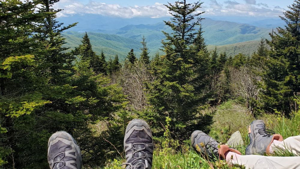
Andrew's Dome Hike
Stepping out of the car it was windy and cold! We put on sweat shirts and rain coats and started the long, steady down hill hike arriving at a grassy open area called Andrew's Dome. The hike started misty and overcast (we liked it) and after a while no need for sweat shirts and rain jackets. Even with all the rain the past few days the trail was wet but not muddy. The trail was built with a lot of logged off openings to allow run off from above to cross the trail without eroding it. Even still, there were spots were water was running right down the trail. The combination of rocks and clay kept it from getting muddy.
Arriving at Andrew's dome we took some time to relax and enjoy the vista views of the Smokies as the clouds started clearing. So lucky being our first clear day (and our last in the park). We only shared the dome with a few college kids on a nature study. After enjoying the views we headed back up the mountain making the steady climb back to the parking lot. The hike was out and back, 4 miles / 883' elevation (seemed like more), and lightly trafficked. Awesome hike!


 VIDEO
VIDEO 


Views at lunch from the parking lot
Back at the parking lot around noon it was jammed! No parking spaces and even all the small overflow parking places along the road were packed. We were glad we got there early. With the sun finally out we relaxed, had our lunch and totally enjoyed the beautiful view. I did not want to leave. We had planned to do the short, steep (.5 mile/ 330' elev) Clingman's dome hike next but, the large crowds, our protesting calves and the long drive back to Columbia made an easy choice to get back on the road.


 VIDEO
VIDEO  VIDEO
VIDEO Scenic views on the way out of the mountains
The scenic drive out of the park and along the Blue Ridge Mountain drive was awesome eventually bringing us out of the mountains (dang). After a four+ hour drive back to Columbia we checked back into the same hotel (we weren't to excited about that). For dinner we ended going back to Backstreets for celebratory beers, anchovy dip for an appetizer and dinner salads, a nice meal.


 VIDEO
VIDEO Friday, May 17
Weather: 60s early, sunny
Travel Day
Early flight so we left the hotel about 6am. About halfway to the airport we hit train tracks with a very long train totally stopped across the road. After waiting a few minutes we decided the train was not going to move. We tried an alternate path but the first time Google Maps just took us back to the tracks! The problem with relying too much on Google Maps! The second attempt got us on a path avoiding the train tracks (whew!).
Flight was on time and uneventful.
Home Sweet Home!
Summary
Columbia is a nice town with a small feel. The Congaree river area is great and would have been better if the trail was open. Lot's of good restaurants.
Hilton Home 2 Suites was not great. Strange layout and terrible breakfast. Charged $14 for parking. I put it on the do not stay list.
Congaree National Park beat our low expectations. The old growth 130+' trees and hiking above a swamp was pretty cool and quietly peaceful. Mosquitoes were no problem on our trip but the black flies required the use of bug spray. Congaree often makes the 10 worst NP lists and I can't argue with that but... if your in the neighborhood ANY National Park is worth the visit. We liked ours.
Great Smokey Mountains National Park was amazing. I was worried that with all the rain our hikes would be mud slogs. Not so, most of the trails were very OK even the ones with water flowing down the path they were not muddy. A rain jacket and waterproof hiking boots are essential. Even the first two days in the rain the hikes were excellent. Particularly liked all the "Foot Log" bridges and we marveled at how the Civilian Conservation Corps were able to construct them. Finally, on the last day in the bright sun, the Smokies were a sight to see. In our 2 1/2 days we hiked four different areas of the park, Oconaluftee Visitor Center North Carolina South entrance area, Greenbrier in the North East section of the park, Sugarlands Visitor Center at the North Tennesee Entrance of the park and the Clingman's Dome Area, the highest point in the park at elevation at 6643' in the center of the park.
Gatlinburg is right outside the West entrance to the park and has nice views of the mountains. Very touristy.
Gatlinburg Airbnd was a great location. The bnb was newly remodeled but they cheaped out on the furniture and no coffee! Kathryn did not mind it but I would not stay there again. I rated it a 4 just because I'm nice (debatable).
All in all a great trip and two more National Parks!